Cartographic Memories pt.1
“It is not down in any map; true places never are.”
- Herman Melville Moby Dick
I just taped a map of Southern Asia to my office wall. Bought on a recent trip to the New South Wales Sapphire Coast, it's a striking A0 sheet of contrasting blues and yellow and oranges - representing 1/10th of the earth at an emblematic scale of 1:5,000,000.
Its addition to my deskscape has pulled me out of a Covid slump more than any regular exercise, good diet and mindfulness has been able to (authors note - this was written mid covid lockdown).
It pulls me back to old memories of old journeys. Do maps - just like Paul Theroux's statement on fiction - really give a life to places in expressive ways that no history book can begin to suggest? I’d say yes, in their own way - but only if you've been there first… Let me elaborate.
But first, lets define maps.

The map
Cartography (the act) and maps (the art) combine science, aesthetics and technique. Maps communicate spatial information in a diagrammatic way that is simply understood. Arguably the purest form of communication - although not without bias - maps eliminate characteristics of a mapped object that are not relevant to purpose. In 1927, J.A Steers astutely pointed out that maps are not copies; they are projections - projections that are not neutral, natural or ‘given’.
Brian Harley quite succinctly defines maps as things, concepts, conditions, processes or events in the human world. Mapping is, and always has been, political. Global commerce, zones of dominion and frontiers of power. It's the stuff of empires.
Maps are an abstraction of the physical or conceptual world - a symbolic depiction of a space or idea that allows one to understand or navigate unfamiliar or complex topography. To be technical about it - a cartographer must choose between zenithal, gnomonic, conical, cylindrical or sinus dial modes of projection. Each having advantages and disadvantages - this is why you will often see Greenland is depicted on a map as being almost as large as Africa - its not. Understanding this highlights the the cartographers problem as the draughtsman's problem - one of perspective. Ptolemy was the first to analyse the problem of these distortions created by trying to lay a spherical object flat. Solved by Richard Buckminster Fuller's Dymaxion World Map - the representation of the world as we know today.
Undoubtedly, methods and representation of cartography have shifted over time, but their ability to inflame, inspire the mind or spark physical action in humans has not. Cartography captures the timelessness of the human condition. And in this case - it's my inflamed mind.
-
The map on my wall - being a map of Southern Asia - was made by the US Army Topographical Command. It depicts India, Ceylon (now Sri Lanka), Burma (now Myanmar), China, Thailand, Pakistan, Nepal and Bhutan. It could be a reverse heat map - the ocean is blue, with the lowland tropics shown as light yellow - whilst Himalayas burn orange to snow line white. Within the boundaries of the map - I note the countries that I have visited - India, Myanmar and Thailand. I begin tracing my travels over the map, now standing on my desk to look closer at these routes - reliving quickly retrieved and fragmented memories of many journeys, certainly appreciating it the second time around. Being quite a visual person, I find looking at the topography, the names of cities and regions has a pull on memories I forgot I had. I easily locate New Delhi on my new map.
-
“India. Hot and chaotic, cheap and delicious, grotesque and poor. The best place I’ve ever been.”
I first travelled to India with a boyfriend in 2014. In my naivety at the time, India was a cliched Eat Pray Love bucket list destination idea activated upon watching Wes Andersons The Darjeeling Limited. Less than a month later, we were on a SpiceJet flight direct to New Delhi. Being 24 at the time, trip route and destination planning was limited to the 2013 edition of Lonely Planet.
Scent, emotion and memory are closely linked. Being both blessed and cursed with having an over enthusiastic olfactory system, India was an affront, a place where sounds and smells never sleep. Our first stop, New Delhi was out of its mind busy in all senses. The young naive Austrlians that we were, resulted in easy pickings for the less honest street life; we got tangled up with some local touts and got scammed on our second day - a situation likely avoided had we done any pre planning.
This life lesson, was fortunately counted with the almost immediate chance meeting with Vince* - the beautiful American gay male escort, who I still consider a good friend. His reaction to bats in our room and my worry as he crossed the Ganga river to party with young local men (homosexuality is quite common before marriage he insists) are the concrete friendships bonds that travel can offer. A vibrant intermittent addition to our intrepid party. There are zero fire escapes - in buildings with high chances of fire - and paper thin balconies that shouldn't exist were pushed aside for some of the best food imaginable. Simple street potatoes rank high on the list. While an amazing cashew paneer and fresh garlic naan in the walls of Jaipur has made all other food to date pale in comparison.
The Taj Mahal - located in Agra - slightly below New Delhi on my map - lived up to the hype. The framed vision as one enters through the vibrant red brick archway is spectacular and an architectural masterclass on vistas. The surrounding slums and greasy, glassy modern buildings of Agra, masterclass be damned.
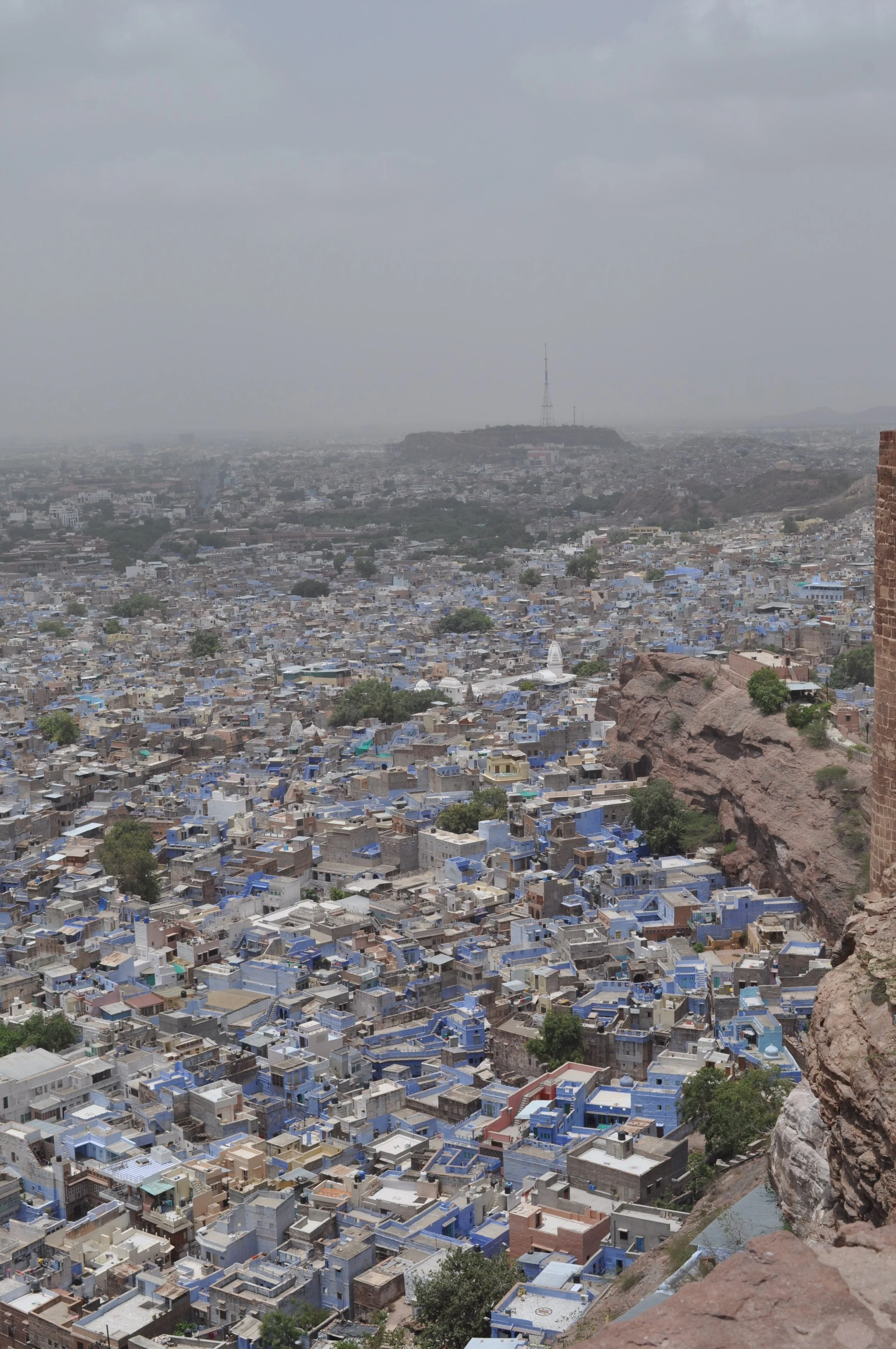
Continuing on my sequential ‘map-journey’ through India, little black labels on a speckled sandy coloured background mark Jaipur and Jodhpur. We travelled for 2 weeks through this dusty golden triangle of Rajasthan, noted on my map with tiny diagrammatic train tracks, via 2nd class train rammed with local company, constant chai and samosas. During this time I developed an admiration for the commitment to colour throughout India. The beautiful, and refreshingly bold, vibrant blue of Jodhpur and the floaty pastel pink of Jaipur reminded me that colour and deliberate, built in ornamentation shouldn't be avoided in design. As architects, we can sometimes become lost to the comforts and commonality that these elements offer to humans.
Though don't get me wrong - the stark, monumental and ‘morally pure’ form certainly has its place - mostly in larger scale public projects. Although wouldn't it be fun to see a new civic building go up, textured in its fenestration with a few stoney gargoyles to watch over the street? But I digress…
Continuing on my past (by train) and present (tracing the map) travels - I carry on South East to Varanasi - the central place in pilgrimage, death and mourning of the Hindu world. Before Varanasi, I had only ever seen a dead body once - my beloved paternal grandma as they took her away from my parents house. This changed soon after entering that old city.
“Varanasi as history, older than tradition, older even than legend, and looks twice as old as all of them put together. And you can feel this.”
Varanasi is one of the world's oldest continually inhabited cities - dating back to 1800 BCE. A city only trafficable by foot or donkey. The shockingly narrow streets wiggle through each other like spaghetti - completely organic in urban growth. Varanasi is the spiritual centre of India and is homebase of the mighty Ganges river. The heartbreakingly toxic, sewage and heavy metal infused Ganges is significant as a place of pilgrimage, death and mourning in the Hindu religion. The belief that dying here and being cremated in one of the Ghats on the river bank breaks the cycle of rebirth and transcendence to salvation. Mark Twain rightly described Varanasi as history, older than tradition, older even than legend, and looks twice as old as all of them put together. And you can feel this.
As you drink your mango lassi, it's in these ancient narrow alleys that you will most certainly be pushed aside by an energetic funeral progression. A flower ladened body being taken to a Ghat to be burned on a pyre - a cathartic and undeniably beautiful celebration of life and closure to death. But also at the same time blase in parts, as young boys of the Dalit or ‘Untouchable’ caste fish for what I assume to be gold fillings in the muddy edges of the Gange where the pyres are pushed when they cease to burn. It’s a spectacle of ceremony and sociology. There's nothing like it.


-
The most potent memories of my time in India is the road from Leh to Srinagar. The part of my new map that I was most keen to locate. This part of the map sharply rises from a sandy yellow to a deep orange and while, the omnipresent of the Himalayers. It takes me a long while to locate Leh on this 6 x 2 cm rectangle of map.
The mountains and valleys are meticulously drawn, as are the rivers leading from secondary tributaries. Yellow immediately turns to red on the map - a clear indication of the Indus-Yarlung suture fault zone line pushing upwards. Studying this Post-it note section of map - I am astounded by how many memories are contained, and triggered by this tiny bit of detailed drawing. Both my own personal memories, and a vast collective human tumultuous history layered in a tiny portion of simple cartography.
Disputed Kashmir, an area that is most keenly aware of arbitrary drawn lines on maps - since Britain in a rushed and subsequently careless action, annexed India, Bangladesh and Pakistan. This partition in 1947 affected over 20 million people and created an overwhelming refugee crisis. The loss of life from associated violence neared 2 million deaths. Kashmir is one of the still disputed territories.
I have to stand on my desk again to see and to trace the journey from the cities of Leh to Srinagar - it's such a tiny portion on the map. Initially I can't find Leh - the beginning of our time in the Ladakh Kashmir region. I have to trace the route in reverse from Srinagar, through Kargil (marked as Kharbu), to Lamayuru - with its amazing moonscapes, to Leh.
To be continued in part 2.
*Names have been changed for anonymity